Mass Balance Factsheet for the Goldbergkees, Alps
Goldbergkees, also known as Vogelmeier – Ochsenkarkees, is a small mountain glacier in the Eastern Alps, situated very close to the Observatory on top of Sonnblick (3105 m a. s. l.) directly at the main Alpine ridge. The glacier covers an area of 0.96 km² (2021), ranges from 3060 m to 2380 m and is now separated into three parts. The upper part (0.25 km²) shares a drainage divide with Kleinfleißkees and is oriented to SE. Both the middle part (0.62 km²) and the lower part (0.09 km²) of the glacier are mainly oriented to NE and exhibit proglacial lakes.
Annual (winter) mass balance observations date back to 1988/89 (1986/87). Average annual air temperature at 3100 m (which corresponds to the average ELA) is -4.5 °C (1991-2020). Measured average annual precipitation at Sonnblick is 2560mm (1991-2020). Average (1991-2020) winter (annual) mass balance of the glacier is 1710 mm (-780 mm). Since a few years, the actual and former state of the glacier can be followed via two high quality webcams: CAM 1 and CAM 2.
For additional information on the status of the glacier and on data relating to annual mass balance and other measurements, visit the WGMS Fluctuations of Glaciers Browser.
FACTS:
- Political unit: AT
- WGMS ID: 1305
- Latitude: 47.04°N
- Longitude: 12.97°E
- Height min: 2380 m a.s.l.
- Height max: 3060 m a.s.l.
- Measurement types: MASS BALANCE, THICKNESS CHANGE & FRONT VARIATION
- Current Principal Investigator: Bernhard Hynek & Anton Neureiter
- Current Sponsoring Agency: GEOSPHERE AUSTRIA, AUSTRIA’S INTEGRATED FEDERAL INSTITUTE OF GEOLOGY, GEOPHYSICS, CLIMATOLOGY AND METEOROLOGY (VIENNA, AT).
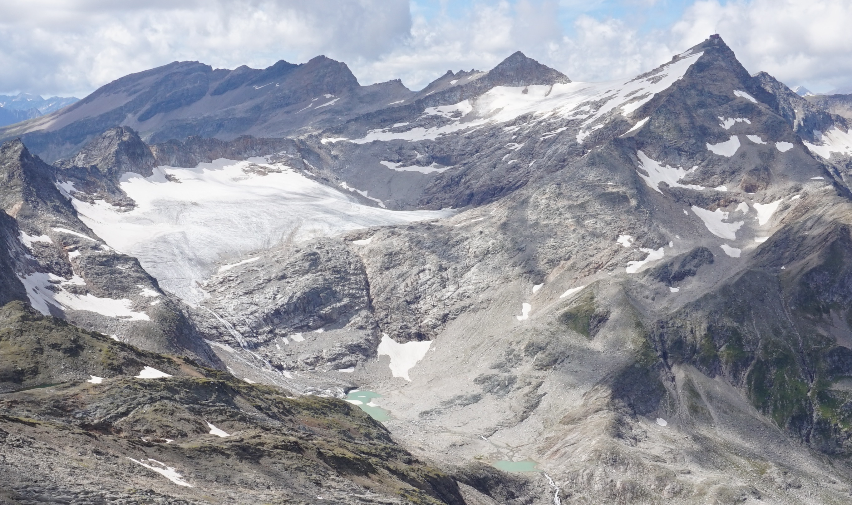
Goldbergkees in August 2020 (taken by Anton Neureiter on 27/08/2020)
Terrestrial and satellite map of Goldbergkees (Google Maps)
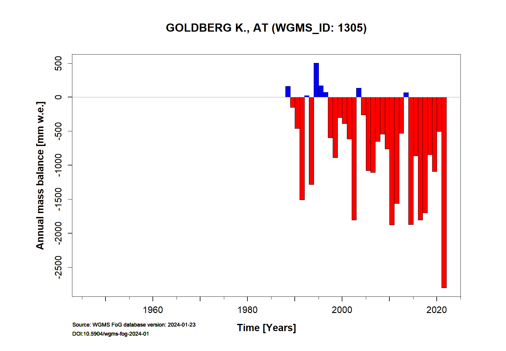
Goldbergkees Annual Mass Balance (WGMS)
Continuous Mass Balance (MB) measurements since 1988/89:
![]()
Additional data available: Front Variation (FV), Thickness Change (TC) and Glacier Outlines:


![]()
Selected references:
Schöner, W., Hynek, B., Böhm, R., Binder, D., Koboltschnig, G., and Holzmann, H.: Glazialhydrologisches Monitoring im Bereich des Rauriser Sonnblicks (Hohe Tauern, Österreich), Österr Wasser- und Abfallw, 61, 1–8, https://doi.org/10.1007/s00506-008-0059-z, 2009.
Schöner, W., R. Böhm, I. Auer und M. Staudinger, 1999: Gletschermonitoring im Sonnblickgebiet. In: Österr. Beiträge zu Meteorologie und Geophysik, Heft 21, Zentralanstalt für Meteorologie und Geophysik.