Mass Balance Factsheet for the Jamtalferner, Alps
Jamtalferner is a temperate valley glacier located in the Austrian part of the Silvretta region close to the border to Switzerland. The glacier covers an area of 2.52 km² (2020) and has three tributaries (exposed to NW, N, and NE) joining into one glacier tongue. In 2018 the highest point of the glacier was at an altitude of 3116 m near Hintere Jamspitze. The terminus reached down to 2428 m, with a length of the main tributary between Hintere Jamspitze and terminus of 2.2 km. The ice thickness was measured by GPR in 2015 and returned a maximum ice thickness of 58 m. In 18 out of 33 years of the total record length, the equilibrium line was above summit. From 2002/2003 onwards, ELA was above summit in 14 out of 19 years, with four years of zero accumulation area. The average summer air temperature, measured at the closest weather station in Galtür (1587 m), is 12.9 °C (June, July, August, 1951-2000), 10.9°C for the summer half year (May-September), and 3.9°C for the hydrological year. Presuming a lapse rate of 0,65 °C/100 m, the summer air temperature at the glacier tongue is 7.4°C. The mean annual precipitation measured at Galtür is 1013 mm.
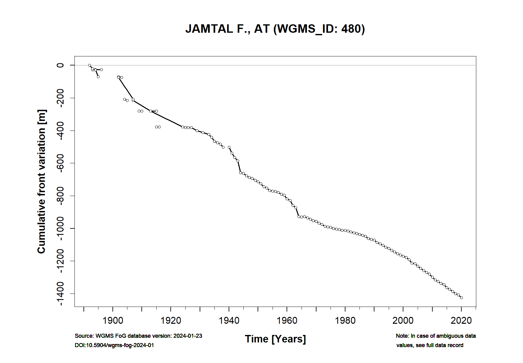
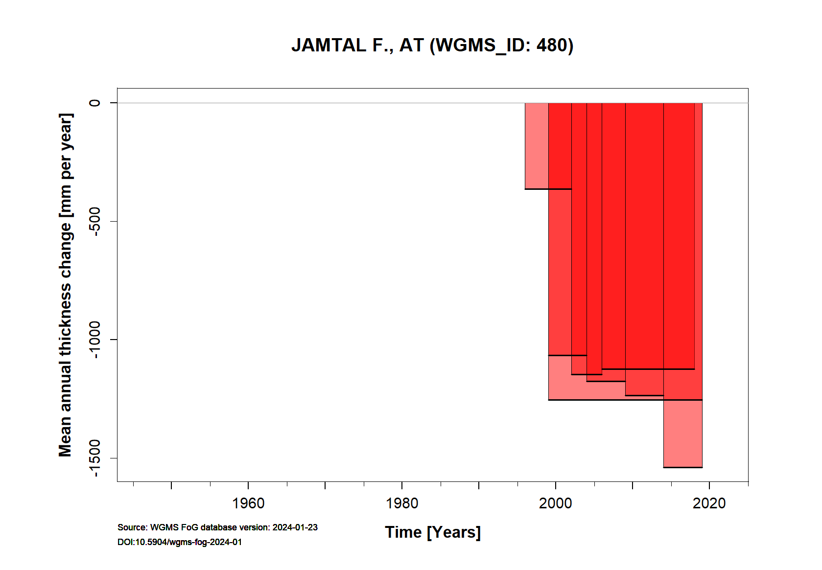
Jamtalferner has been surveyed regularly since 1891 (Fischer et al.2016a, Fischer et al., 2018), with detailed winter and net mass balance measurements since 1988/89 (Fischer et al., 2016b). The network includes around 9 4 snow pits and around 10 20 stakes. The number of snow pits has decreased and the number of stakes increased over the measurement period because in recent years net accumulation takes place at only one of the former snow pit locations and that only occasionally. Surface topography has been documented in a number of maps and DEMs from the early 19th century onwards (Fischer et al., 2019). If we take the glacier area of 1988/89 as reference, Jamtalferner has lost 34% of this area over the total length of mass balance records. The downwaste of Jamtalferner is rapid, with the glacier tongue going to lose the connection to the higher areas in the next couple of years. For additional information on the status of the glacier and on data relating to annual mass balance and other measurements, visit the WGMS Fluctuations of Glaciers Browser.
FACTS:
- Political unit: AT
- WGMS ID: 480
- Latitude: 46.86°N
- Longitude: 10.15°E
- Height min: 2428 m a.s.l.
- Height max: 3116 m a.s.l.
- Measurement types: MASS BALANCE, THICKNESS CHANGE & FRONT VARIATION
- Current Principal Investigator: Andrea Fischer, & Colleagues
- Current Sponsoring Agency: INSTITUTE FOR INTERDISCIPLINARY MOUNTAIN RESEARCH, AUSTRIAN ACADEMY OF SCIENCES. The measurements are supported by the Hydrographical Survey of the Federal Administration of Tyrol and the Verein Gletscher und Klima.
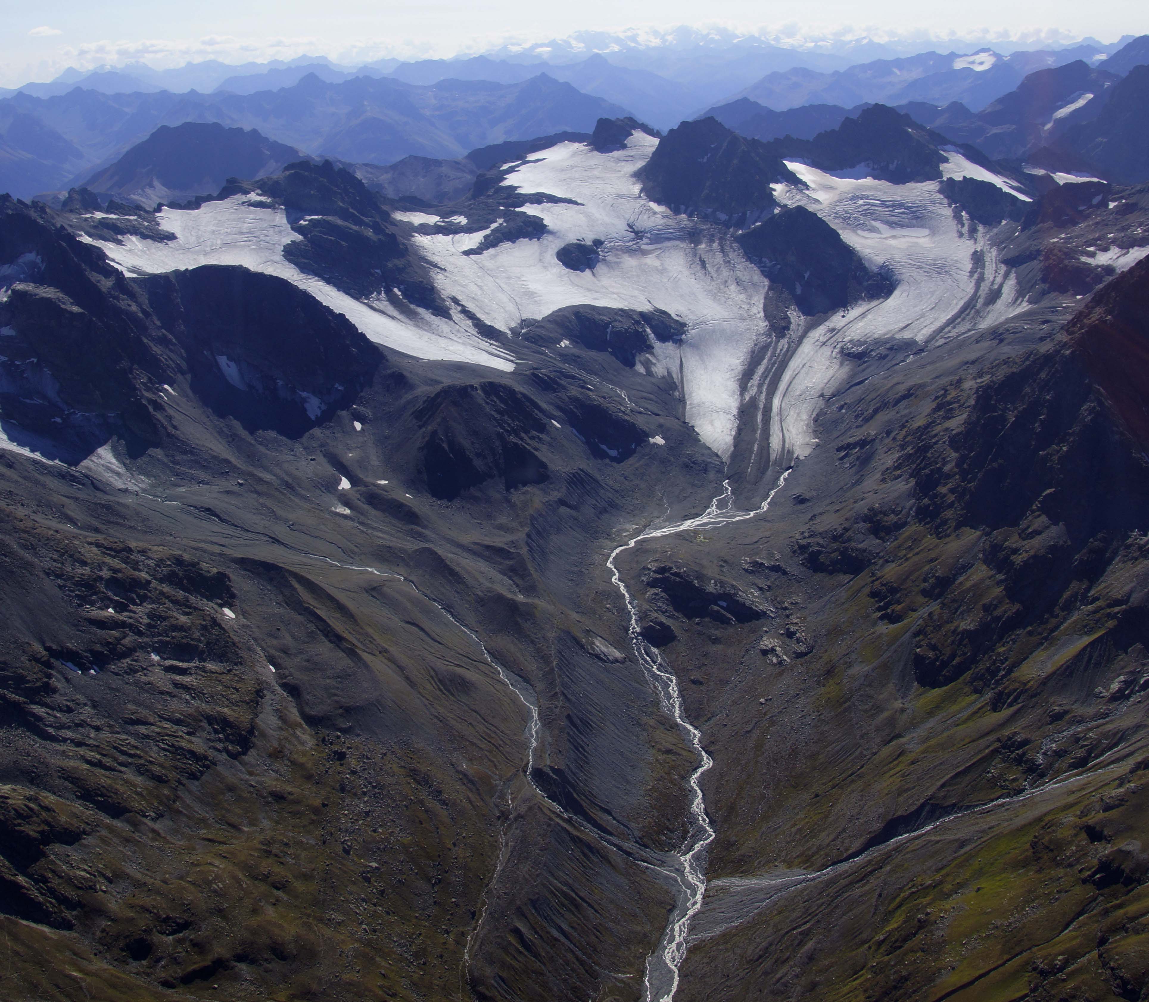
Jamtalferner on 20.09. 2018 (photograph taken by Andrea Fischer)
Terrestrial and satellite map of Jamtalferner (Google Maps)
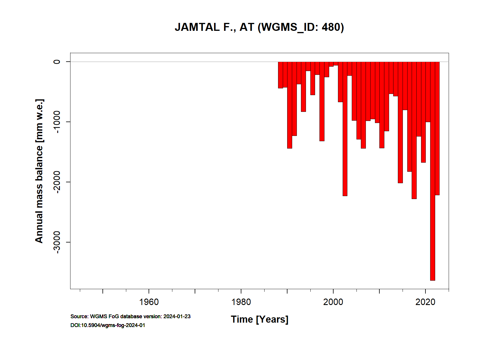
Jamtalferner Annual Mass Balance (WGMS)
Continuous Mass Balance (MB) measurements since 1988/89:
![]()
Additional data available: Front Variation (FV), Thickness Change (TC) and Glacier Outlines:


![]()
References
Fischer, A., K. Helfricht, H. Wiesenegger, L. Hartl, B. Seiser, M. Stocker-Waldhuber, 2016a. Chapter 9 – What Future for Mountain Glaciers? Insights and Implications From Long-Term Monitoring in the Austrian Alps, In: Gregory B. Greenwood and J.F. Shroder, Editor(s), Developments in Earth Surface Processes, Elsevier, 21, 325-382. http://dx.doi.org/10.1016/B978-0-444-63787-1.00009-3.
Fischer, A., Hartl, L., Markl, G., Kuhn, M., 2016b. Glacier mass balances and elevation zones of Jamtalferner, Silvretta, Austria, 1988/1989 et seq. Institut für Interdisziplinäre Gebirgsforschung der Österreichischen Akademie der Wissenschaften, Innsbruck, PANGAEA, https://doi.org/10.1594/PANGAEA.818772
Fischer, A., G. Patzelt, M. Achrainer, G. Groß, G. K. Lieb, A. Kellerer-Pirklbauer & G. Bendler, 2018. Gletscher im Wandel: 125 Jahre Gletschermessdienst des Alpenvereins. Springer Spektrum, 140 S. doi:10.1007/978-3-662-55540-8. http://www.springer.com/de/book/9783662555392.
Fischer, A., Fickert, T., Schwaizer, G. et al. Vegetation dynamics in Alpine glacier forelands tackled from space. Sci Rep 9, 13918 (2019). https://doi.org/10.1038/s41598-019-50273-2
Selected references: tba