The WGMS is in charge of compiling changes in glacier length, area, volume, and mass, primarily based on in-situ measurements. However, an increasing number of glacier-related research projects nowadays produce data from mostly space-borne remote sensing sensors. Combined with the existing in-situ network, these studies complement the multi-level glacier monitoring strategy of GTN-G. The WGMS actively fosters glacier observations from space through the following initiatives:
Copernicus Climate Change Service
![]()
![]() Copernicus is Europe’s flagship programme to monitor the Earth and her many ecosystems (Copernicus). Copernicus delivers freely accessible operational data and information services in six thematic areas (land, marine, atmosphere, climate change, emergency management, security) based on the Sentinel satellites and other contributing space missions as well as “in-situ” (meaning local or on-site) measurement sensors on land, sea and air to provide huge amounts of earth observation data.
Copernicus is Europe’s flagship programme to monitor the Earth and her many ecosystems (Copernicus). Copernicus delivers freely accessible operational data and information services in six thematic areas (land, marine, atmosphere, climate change, emergency management, security) based on the Sentinel satellites and other contributing space missions as well as “in-situ” (meaning local or on-site) measurement sensors on land, sea and air to provide huge amounts of earth observation data.
In 2017, the WGMS and the Department of Geography, University of Zurich, together with Gamma Remote Sensing, the University of Oslo and the US National Snow and Ice Data Center (NSIDC) started to contribute glacier data and information to the Copernicus Climate Change Service C3S. Since then, we integrated data products related to glacier distribution (inventory) and glacier change (elevation and mass change) into the C3S Climate Data Store (CDS). The former included the provision of a global glacier inventory, the Randolph Glacier Inventory (RGI 6.0), as well as, the creation of new regional inventories for several regions (e.g., Alps, Svalbard, Franz-Josef-Land) using Sentinel-2 and other sensors. Regarding glacier change, we provided the available glacier volume and mass change series from the Fluctuations of Glaciers (FoG) database.
In the new project phase, C3S2 starting in spring 2022, the WGMS and the Department of Geography, University of Zurich, have contributed to the production and brokering of the newest version of the global glacier inventory (RGI 7.0) in vector as well as in raster format to facilitate the usefulness of this dataset for CDS users and climate models. Additionally, we are combining glacier volume and mass change series from the latest version of the FoG database into a global gridded glacier mass-change product. Furthermore, C3S allows improving and extending the global glacier inventory and will boost the compilation and computation of glacier volume changes using space borne sensors.
G3P: Global Gravity-based Groundwater Product
Funded by the EU Horizons 2020 program, the G3P project aims at developing a global product of groundwater storage variations from satellite gravimetry. The strategy consists in subtracting four of the main continental water storage compartments – Glaciers, Snow, Soil moisture and Surface water bodies – from the Gravity Recovery and Climate Experiment (GRACE) total water storage signal, obtaining Groundwater variations as a residual. Being part of the G3P consortium, the WGMS working group at University of Zurich, will contribute with the development of a purely observational global glacier change product readily extractable from the GRACE signal. During the project period from 2020 – 2023, our main goal is to combine the Copernicus Climate Change glacier services (glacier outlines and glacier volume and mass change series) into a global assessment of glacier mass changes at an improved spatial (individual glacier) and temporal resolution (annual-seasonal-monthly), with yearly updates. The finished glacier product will be available for further academic research involving recent local, regional and global glacier changes.
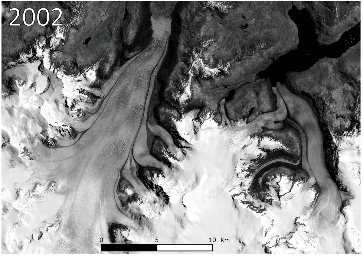
Retreat of Jorge Montt glacier (Patagonia, Chile) observed from space (E. Berthier from ASTER images)
Glacier Mass Balance Intercomparison Exercise (GlaMBIE)
![]() As a contribution to ESA’s Polar Science Cluster, a consortium consisting of the WGMS, the University of Edinburgh, and Earthwave is in charge of the “Glacier Mass Balance Intercomparison Exercise” (GlaMBIE). The GlaMBIE project builds on nascent efforts within and directly contributes to the IACS working group on Regional Assessments of Glacier Mass Change (RAGMAC) to set up and coordinate an intercomparison exercise of regional glacier mass changes from glaciological in-situ measurements and various remote-sensing sources, including geodetic DEM differencing, altimetry, and gravimetry. The aim of GlaMBIE is to develop an assessment framework, algorithm, and environment to compile and analyse the regional glacier mass-change results from the active research groups – which are building the RAGMAC community – and to come up with new consensus estimates of regional and global glacier mass changes and related uncertainties. The corresponding results and visuals will be developed in close collaboration with a the GlaMBIE Stakeholder Board, staffed with representatives from different users (e.g., BAMS, C3S, WMO, IPCC). In addition, a roadmap will be prepared for future development of the assessment in the timeframe 2024–28 and a community white paper to promote a large scientific European and/or international effort building on the lessons learned from GlaMBIE.
As a contribution to ESA’s Polar Science Cluster, a consortium consisting of the WGMS, the University of Edinburgh, and Earthwave is in charge of the “Glacier Mass Balance Intercomparison Exercise” (GlaMBIE). The GlaMBIE project builds on nascent efforts within and directly contributes to the IACS working group on Regional Assessments of Glacier Mass Change (RAGMAC) to set up and coordinate an intercomparison exercise of regional glacier mass changes from glaciological in-situ measurements and various remote-sensing sources, including geodetic DEM differencing, altimetry, and gravimetry. The aim of GlaMBIE is to develop an assessment framework, algorithm, and environment to compile and analyse the regional glacier mass-change results from the active research groups – which are building the RAGMAC community – and to come up with new consensus estimates of regional and global glacier mass changes and related uncertainties. The corresponding results and visuals will be developed in close collaboration with a the GlaMBIE Stakeholder Board, staffed with representatives from different users (e.g., BAMS, C3S, WMO, IPCC). In addition, a roadmap will be prepared for future development of the assessment in the timeframe 2024–28 and a community white paper to promote a large scientific European and/or international effort building on the lessons learned from GlaMBIE.
ESA Climate Change Initiative
![]() In the framework of ESA’s Climate Change Initiative, the WGMS has the responsibility of implementing Option 5 to the “Glaciers_cci” project. Option 5 runs from Oct 2015 to Sep 2017 and aims at making remotely sensed data of geodetic glacier changes available to the scientific community in a standardized format. Within the project’s framework, the WGMS establishes the required expertise and extends the existing database infrastructure with a pilot study to house both glacier-wide and gridded data on glacier elevation changes based on known studies from the body of literature. Semi-automated algorithms are under development for adding existing and upcoming data to the Fluctuations of Glaciers (FoG) database of WGMS. Already in the ongoing development phase data are incorporated and made available. Major Goals
In the framework of ESA’s Climate Change Initiative, the WGMS has the responsibility of implementing Option 5 to the “Glaciers_cci” project. Option 5 runs from Oct 2015 to Sep 2017 and aims at making remotely sensed data of geodetic glacier changes available to the scientific community in a standardized format. Within the project’s framework, the WGMS establishes the required expertise and extends the existing database infrastructure with a pilot study to house both glacier-wide and gridded data on glacier elevation changes based on known studies from the body of literature. Semi-automated algorithms are under development for adding existing and upcoming data to the Fluctuations of Glaciers (FoG) database of WGMS. Already in the ongoing development phase data are incorporated and made available. Major Goals
- Establish the expertise and infrastructure to integrate remote sensing data into FoG
- Substantially increase the number of geodetic glacier mass balances in FoG
- Adapt the Cogley literature database to improve FoG literature referencing
- Establish a database link between FoG and GLIMS
TanDEM-X for glacier research and monitoring
TanDEM-X together with the TerraSAR-X satellite is a radar-based Earth observation mission conducted jointly by the German Aerospace Center (DLR) and Airbus Defence and Space. Orbiting the Earth at an altitude of around 500 km, the two nearly identical satellites aim at generating an accurate three-dimensional image of the Earth’s surface with 12 m spatial resolution and a vertical accuracy better than 2 m. The WGMS encouraged its network of Principal Investigators to participate in a first scientific exploitation of the global DEM product of the TanDEM-X mission for glacier monitoring: here
Pléiades Glacier Observatory
Launched by the French Space Agency (CNES) in December 2011, Pléiades is a constellation of two satellites providing optical images of any point on the globe. Products include ortho-images and digital terrain models with sub-metre resolution and precision, respectively. In coordination with LEGOS and the WGMS, glaciologists can acquire stereo data of selected benchmark glaciers at the end of the melt season. So far, two acquisition campaigns (fall 2016, spring 2017) are completed and a third (fall 2017) one is in preparation.
IACS Working Group on Regional Mass Change (RAGMAC)
This working group is set up for the time period from 2020 to 2023 and aims to assess regional glacier mass changes using various observation technologies with the ultimate goal to obtain new consensus estimates of global glacier changes and related uncertainties. More information is found on the corresponding IACS webpage.